

On a lonely stretch of Route 66 east of Newberry Springs, California stands a sign. It’s not much of a sign and, as the years go by, it’s becoming even less of one. It sags in the middle as if one good gust of wind would destroy it forever but it’s still just possible to read CAFE MOTEL with an arrow beneath. Now that arrow points to nothing but desert and the remains of an old trailer, but once this was quite literally a Desert Oasis.
In his A Guide Book to Highway 66, Jack Rittenhouse notes two gas stations at this point within a half mile of each other, one ‘with cafe, few cabins and garage’ and the other ‘similar but lacking a garage’. Rather frustratingly, at a time when every clutch of houses merited its own name, Mr Rittenhouse doesn’t cite place names but in 1939, seven years before his book, the Federal Writers Project of the Works Progress Administration produced a guide to California in which it names two places, Mojave Water Camp and Guyman (‘each has its small knot of sun-bleached buildings’) which are very likely the sites of Rittenhouse’s two stations.
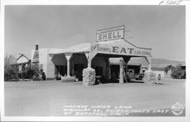
The Mojave Water Camp service station. Note the cabins to the left of the main building.
It’s also likely that, by the time the Guide Book to Route 66 was published, the Mojave Water Camp no longer existed. The last tangible evidence of its existence is in a 1939 photograph by Burton Frasher which shows a Shell station and cafe with a small row of cabins beside it. Some sources say that two service stations were incorporated into one, but contemporary reports speak of two separate establishments a half mile apart.
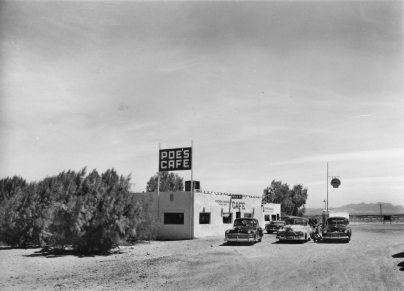
Poe’s Cafe in 1949.
Down the road from the Mojave Water Camp, the gas station at Guyman was bought and redeveloped by Ed Poe, who built a new modern cafe building which proclaimed POE’S CAFE in a square sign and advertised chicken dinners on the front of the cafe. From there on, the place was always known as Poe’s Cafe and the area became generally known as Poe or Poe Town. By 1949, it was ‘Poe’s Cafe and Continental Bus Stop’ and sold Shell fuel although, according to a legal notice in the Bakersfield Californian the following spring, it was by then a Texaco station. A few cabins – or the motel – were added on the side of Route 66.
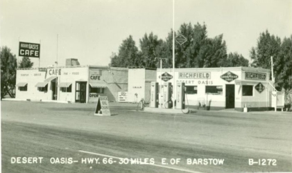
The Desert Oasis Cafe in the 1950s, to judge by the gas pumps. The Poe’s Cafe sign has been replaced and awnings fixed over the windows, while the gas station now retails Richfield fuel.
Poe sold the business in the early 1950s and it was renamed the Desert Oasis, although the name never really took. To the end of its days, the place was known as Poe’s Cafe. Once again, it changed brands, becoming a Richfield station. However, as with other places along the busy highway, not all travellers were filled with good intentions and a desire for a piece of home-cooked pie. In September 1952, a waitress at Poe’s Cafe fell to talking with 33-year-old Robert Elmer Jensen. He persuaded her into his car with the promise of a better job and then took her on a 24-hour ride during which he raped her twice. The waitress managed to escape although she would never have to testify against Jensen who was shot dead by Pennsylvania state police a month later.
Five years later, Poe’s service station – the name Desert Oasis didn’t catch on with the San Bernadino County Sun newspaper – was destroyed by fire after all three pumps caught fire on the evening of 17th April 1957. Fire department units from the nearby Marine Base and the California Department of Forestry at Hesperia found the service station engulfed by fire but they managed to save the cafe, which the San Bernardino County Sun was still calling Poe’s Cafe when, in 1974, it reported on two Daggett juveniles breaking in and stealing food stuff.
From then, Poe’s Cafe quietly disappears into history. Except for that crumbling and broken sign on the side of the highway, for that very sign was intended to entice travellers off Route 66. And then, of course, there was no more Route 66 and no-one wanting to stop for a bed or pie, but the sign still carries on doing its job, long after Poe’s Cafe had vanished into the desert.

All that’s left of Poe’s Cafe, service station and motel.

Full of atmosphere Blue, I enjoyed the read, thank you
LikeLiked by 1 person
Thoroughly enjoyed that. Thanks Blue. CHEERS !!
LikeLiked by 1 person
Not unlike Cadiz, where my mother lived in the 30s
Now mostly dust.
LikeLiked by 1 person
Sadly very little left now. How old was your mother when she lived there, Mr Terrell?
LikeLike
Really enjoyed your story, brought back memories. As a kid in the late 60’s ours and a few other families used to spend Thanksgiving out in that area, Poe’s place was our landmark to turn off and find our little cove.
LikeLike
Thank you sir!
LikeLike
I really enjoyed this. It’s where my life started as I myself lived there with my parents, Ed and Alta Mae Poe and my brother, Jimmie and Grandma Poe, Mary Anna May Poe. We sold the place in 1952 and moved to a section of land near Centralia, Missouri. We moved again after three years to Chicago, Illinois and my dad became a licensed Real Estate broker. We couldn’t take the cold so the family sold and once again settled in Newberry Springs, Calif. IN 1954 my dad bought a place from Ernest and Dixie Summers and remodeled the building turning it into a very nice restaurant and Cocktail Lounge along with Continental Trailways Bus stop. It was the families second restaurant business of four.
LikeLike
Hello – Can you tell me exactly where Poe and your parent’s buildings were on a map? I see the Poe site demarcated on a 1982 USGS Troy Lake Quadrangle Map. Were the buildings there on the south side of Route 66, or were the buildings on the north side of Route 66 closer to the Interstate 40 rest stop?
LikeLike
Yes most all the buildings were on the north side on 66, the well and high water tower and our motel was on the south side. Dad also built two more concrete slab foundations on each side of the existing motel so there would have been three buildings in all in the form of an arch. The water tower was torn down and moved to Barstow. It is located on the Mc Donald’s property off East I-15 close to the 15 and I-40 interchange. The original water tower was much taller than it is now.
LikeLike
Hi, I am Jimmie Poe , there is nothing left of my Dad & Mom’s old place , but the division of highway we’re going to put an off ramp there at one time . There is a rest stop there on Interstate 40 that is about one eighth of a mile north west of me Dad’s old place. Also there is a natural gas pipeline road north of the sight and part of it was an air strip. Our town was on the state air maps. Dad had an airport there and he had his own Navion airplane. There was a small cafe and motel one mile west of us owned by Mr Bob Banks and his family.
LikeLike
Hello, Jimmie,
I just discovered this WordPress exchange but it is two years later (2021) so I don’t know if you monitor this and can reply. I collect matchcovers from Route 66 and I have an old matchcover from Poe’s that indicated that they sold Shell gasoline and the matchcover indicates that Poe’s was “30 Miles East of Barstow” on US Highway 66.” That sounds about right.
I also have a matchcover from Smith’s Silver Valley Station which included “Café – Gas – Cabins” and it was also “30 Miles E. of Barstow.” This matchcover looks to be from the 1950s or so. This matchcover does not say “Highway 66” on it anywhere though. Do you know about this business? I can’t find any reference to “Smith’s Silver Valley Station” on the internet at all.
LikeLiked by 1 person
Greetings Phil,
My name is Amin Eshaiker. I’m not sure if you remember me but we used to e-mail about historical locations on Route 66 in the Mojave Desert. Just sending this e-mail to see if you are still out there. Would be good to catch up. Hope you and your family are safe.
LikeLike
Hello, Amin,
I do remember you from years past. It’s good to hear from you again. I no longer have a record of our email exchanges but I do have an email exchange from Joe de Kehoe back in 2008. And I know you were a friend of Joe de Kehoe. In fact you contributed an image of a Roy’s in Amboy postcard to his book The Silence and the Sun.
I have expanded my Route 66 website over the years so check it out if you have not seen it for a while.
http://rt66.x10host.com/
I just posted an image of this Smith’s Silver Valley Station matchcover on my own website and asked people if they knew anything about it. Scroll way down to near the bottom of this webpage:
http://rt66.x10host.com/matchcovers/themes.html
I wonder if Joe de Kehoe would know anything about this gas station?
Phil Gordon
LikeLiked by 1 person