THE HIDDEN SIDE OF HACKBERRY

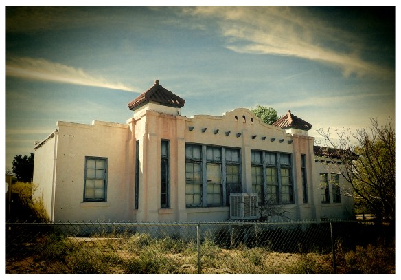
With its Mission-style architecture, the school was the grandest building in town.

Almost every traveller on the section of Route 66 between Seligman and Kingman, Arizona, stops at the famous Hackberry General Store. But few realise that there is more to Hackberry than a cold soda and some picturesque photo opportunities with old cars. Just to the south of the General Store and Route 66 lies the remains of what was, from 1874 until shortly after the Great War, a thriving town.

Originally a mining camp at the foot of the Peacock Mountains, Hackberry supported the twin trades of ranching and mining – indeed, it was the former that brought the railroad to Hackberry in 1882, as much to transport cattle as to carry ore from the Hackberry Silver Mine. By the time the mine closed, some $3 million of gold and silver had been dug out and perhaps one of the obvious indications of the temporary prosperity of the town can be seen in its now disused elementary school.

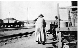
By the time this photo was taken in 1924, the school had been open for 7 years. Sadly, I don’t know whether the teacher is the ‘pleasant young Miss Jones’. Photo courtesy of the Mohave Museum of History and Arts

At a time when most schools were little more than wooden shacks or barns (for example, the Red School in Valentine to the west), the community of Hackberry commissioned a rather grandiose stone building. In May 1917, the School’s Board of Trustees called for bids for the erection of ‘a one-story public school building, to accommodate at least 80 pupils and cost not to exceed Seven Thousand Dollars; building to include all necessary wardrobe closest, teacher’s room, library room, etc, and to have chimney and fresh air vents for heating and ventilating purposes and to be as nearly fire-proof as the sum to be expended will permit.” You have to love that ‘nearly fire-proof’, but clearly not if it was going to cost more money!

The design that was accepted turned out to be a quite ornate Mission-style building with red roof tiles, two tiny decorative towers and even a Spanish-style bell. Nor did the Trustees hang about once having made a decision. At the end of August 1917, the Mohave County Miner reported that contractor Axel Ericson was completing the cornice work on the school (incidentally, Mr Ericson had just won the contract for his next job, which would be installing radiators and steam heating in the Hotel Brunswick in Kingman).

The bell still seems operational, but I decided not to try…

The school had two classrooms, two bathrooms, a kitchen and living quarters for a teacher, one of the first of whom was a Miss Jones who, a visit to Kingman being enough of an occasion to make the local newspaper, was described as ‘a pleasant young teacher’. To the young children who attended Hackberry Elementary School – they ranged from kindergarten age to the 8th grade – the building must have seemed almost like a castle. Teachers came and went; children grew up but often stayed in the town. Many of them were Griggs and several generations of that family were taught in the school. In fact, virtually everyone in Hackberry now (although that’s only around 20 people) is either a Grigg or related to the family.

An abandoned basketball hoop beside the school.

But, by 1994, the Board of Trustees (all of them, by the way, retired and without children in the school) decided that the little school should be closed. The parents of the 22 remaining pupils fought the decision but without success, even though the reasoning seems in hindsight a little vague. Joseph Averna, one of the three Trustees called the school ‘inefficient and ineffective’ (it quite possibly was, the tendency to follow the curriculum was, by all accounts, less than enthusiastic) and, on the eve of the meeting to decide the future of the Hackberry Elementary school, proclaimed; “We are going to drag [the parents] kicking and screaming in the 20th century. The people who pay the bills want the school closed.” He then went on to admit that no-one had actually looked at a budget, nor did they know how much money would be saved by the closure. Nonetheless, the decision to shut the school was made the following day.

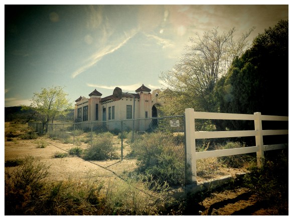
Today children are bussed to schools miles away, leaving Hackberry as more of a ghost town than ever, while the school – which is owned by the Grigg family – stays resolutely shut and fenced off. The family hopes one day to refurbish, but no new generation of Griggs will ever be taught there.

Hackberry Elementary School, still as if the children had just left for the day.

NOT QUITE SUCH A SHORE THING

Half close your eyes, ignore the smell of rotting fish and you could see why this was such a popular place in the 1960s. The pilings to the left are the remains of the boat jetty.

The North Shore Beach and Yacht Club began construction in 1958 at a time when that accidental sea, the Salton Sea, was an up-and-coming destination and not the dead fish-ridden wasteland that much of it has become today.

Back when it looked like the resort would last forever.

Back in the 1950s, there was a multi-million dollar plan for what would become California’s largest marina and the jewel in the crown was the yacht club, designed by architect Albert Frey who was responsible for ‘desert modernism’ and whose influence on Palm Springs remains to this day. Frey delighted in the idea of creating a ship in the middle of a desert by a sea that shouldn’t exist, and his design is evocative of a boat with a curved prow, mast, crow’s nest lounge and porthole windows. It soon became popular, promoted as ‘The Glamour Capital of the Salton Sea’, and Dean Martin, Frank Sinatra, Jerry Lewis, the Beach Boys and the Marx Brothers all visited the club.

Bereft of its nautical flags and Albert Frey’s signature yellow fibre glass panels.

One of the developers who built the yacht club was Ray Ryan, who had been responsible for the restoration of the El Mirador Hotel in Palm Springs and later opened the Bermuda Dunes Country Club. Ryan was a flamboyant character who, it was whispered, had connections to the Mob. Stepping out of the Olympia health club in Evansville, Indiana on 18th October 1977, he got into his new Lincoln Continental Mark V coupe and turned the key. The car exploded. Ryan was killed immediately, the power was knocked out over the south part of Evansville and it took two days to find all the pieces of the Lincoln.

From a LA Time supplement of April 1963. The yacht club is in the middle left, with the pool clearly visible. The jetty was destroyed in 1981, and the motel at the top of the picture in late 2008.

Without Ryan, it’s unlikely that North Shore would have been the destination spot that it became in the 1960s, but even he could do little about the twin forces of a recession and environmental problems, both of which ensured the resort’s downfall. As the development boom went bust in the 1970s, countless lots were simply abandoned, while water pollution saw the number of visitors fall. Flooding compounded the area’s problems and, in 1981, a flood destroyed the North Shore Marina’s jetty. If people couldn’t dock their boats, they wouldn’t visit. Many took their boats away from the Salton Sea entirely as they found the increased salinity clogging expensive marine engines.

By 1984, the yacht club was forced to shut its doors. Eventually it fell prey to vandals who exacerbated the interior damage caused by its use as a film location in 2005 (the front was also painted with the name ‘Aces & Spades’ for the movie The Island and the inside gutted) and to skateboarders who treasured the yacht club’s now-empty swooping pool.

The North Shore Motel close to the yacht club. The motel was torn down a few months after this photo was taken.

But that’s not quite the end of the story. The North Shore Yacht Club looked like this when I first visited in 2008. There was a large motel nearby, albeit also boarded up. When I returned three years later, the motel had been razed to the ground but, to my surprise, the yacht club had been restored to its former glory. It was, apparently, intended for use as a community centre and home to the Salton Sea History Museum. But here’s the rub; the owners of the property terminated the museum’s lease after a handful of years, forcing the museum into (hopefully temporary) closure, while every time I’ve been there, the place has been firmly shut up with no indication of any future community events to be held there.

If a club designed to look like a ship in the desert was incongruous, the site of a restored and repainted disused building at North Shore is even odder still.

The North Shore Beach & Yacht Club in 2008.


The North Shore Beach & Yacht Club in 2014.


The famous pool, now gone.

THE INTERNATIONAL CAR FOREST

File0500
In a town noted for its otherworldness, the International Car Forest of the Last Church stands out in Goldfield. Once the biggest town in Nevada, Goldfield is now a place people pass through, although not too quickly. The local police force is noted for its enthusiasm in enforcing the speed limit.

IMG_7006
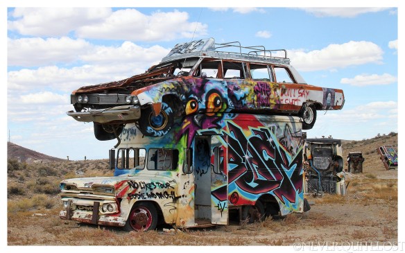
But on the southern edge of town is a place that’s part art installation, part modern graveyard. The International Car Forest was the work of Chad Sorg and Mark Rippie. Rippie owned the 80 acres of land next to Highway 95 and enlisted Sorg (who fell in love with Goldfield and would move there in 2004) in an ambitious project to set the world record for the most upturned cars in an art work, primarily to beat Carhenge in Alliance, Nebraska. Rippie also owned over 40 cars, trucks and buses. Trust me, this is not particularly unusual in Goldfield.

File0475Work began in 2002 and continued over the next decade, using a back hoe and a lot of hard work to ‘plant’ the vehicles. Some were posed nose into the ground, some balanced on the top of others, some poised over mounds of earth. The idea was that the site would be a blank canvas for artists and would inspire graffiti, rather as the better-known Cadillac Ranch ending up doing.

IMG_6982
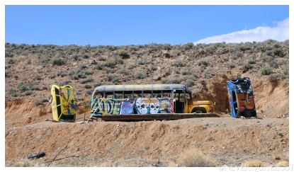
But, unlike that Texas landmark, the International Car Forest seems, for the most part, to have attracted people with some artistic flair. Most of the cars and buses have been painted with designs rather than having names scrawled badly in spray paint. It’s probably the fact that the International Car Forest is in the middle of nowhere – and once you get to nowhere you have to traverse some pretty potholed roads – that has protected it from becoming a eyesore like Cadillac Ranch.

File0469Unsurprisingly, considering that they were two diametrically opposed personalities, Chad Sorg and Mark Rippie’s partnership did not end well. Sorg is an artist who had a vision for the International Car Forest; Rippie just wanted his name on a Guinness World Record. They fell out irrevocably not long before Rippie went to prison for two years for improperly possessing and attempting to purchase firearms. He had been found not guilty of a 1970 armed robbery in Colorado by reason of insanity, something he neglected to tell a dealer in 2010 when purchasing a gun. In 2013 he was arrested at his home in Goldfield where police found with 15 firearms, including two loaded semi-automatic assault-type rifles with extended 30-round clips and a loaded semi-automatic .40 caliber pistol and over 22,000 rounds of ammunition. The court was told Rippie was well-known to law enforcement and others in the Goldfield and Tonopah areas.

File0459Chad Sorg is still an artist and blogger. He has never been found insane. Mark Rippie is out of jail and living in Goldfield where he describes himself as ‘a fat old man with a shit load of guns and ammos’. And quite a few cars that don’t work…


File0491

GHOST SCHOOL IN A GHOST TOWN


The front entrance still looks as spruce as it must have done in 1928.

Lela in Texas always struggled against the odds. Known to some people who travel Route 66 as the home of E Mike Allred’s Regal Reptile Ranch (see the Never Quite Lost post, Snakes on a Plain), it lost out all around to its more glamorous neighbour, Shamrock.

Lela was established in 1902 as a stop on the Chicago, Rock Island & Gulf Railway, when it was originally called Story. It then gained a newspaper – the Wheeler County Texan – and a small school. Then, the ultimate mark of a settlement came along; a post office. Folklore has it that the young postmaster, a young Texan by the name of Bedford Forrest Bowers, changed the town’s name to Lela in honour of his sister-in-law.. However, there’s a few holes in that story. The town was already called Lela when Bedford was appointed postmaster on 9th June 1903. He was 25 years old at the time and there is no record of him having a wife. He did have two older brothers, but David was married to Maud and Isaac to Anna Pearl, neither of which lead themselves to a contraction of Lela.

Whatever the origin of the name, there was a school in Lela (although the dedicated school wasn’t built until 1907), and the first teacher was the splendidly named Fannie (or Frances) Womble. Miss Womble was barely 20 years old when she assumed that position and was soon married to Lucian Purcell, a relative of John Purcell, one of the school’s trustees. Sadly, the marriage would be cut short. In 1903, Fannie suffered a miscarriage, but two years later she gave birth to a son, Farrel. Complications set in and just ten days after the birth, on 16th February 1905, Fannie died. It was a week after her twenty-third birthday. Little Farrel struggled on, but on 9th May 1905 he too succumbed.

Lela would suffer another loss the following year when Bedford Bowers died, aged just twenty-eight. But already the town was beginning to lose out to nearby Shamrock. Although the discovery of natural gas would bring short-lived renewed prosperity to Lela, gradually both trade and residents began to move to Shamrock. But it was while Lela was undergoing this brief boom that its school burned down. At the time, the town was large and prosperous enough to warrant the building of a fine brick school which would accommodate all grades. However, by the 1930s, it was catering only to the younger children, as the high school students decamped to – yes – Shamrock.

One of the gas stations which sprang up to serve Route 66. It limped on in its last years as JD’s Service Station before falling into disrepair.

Route 66 would bring another infusion of life into Lela, as two gas stations were opened. But it didn’t last. By 1947, there were only 50 people left in Lela; the school and the church staggered on but the remaining businesses gradually closed. Even the newspaper moved down to Shamrock.  In 1976, Shamrock took its final victory over its neighbour as the post office was transferred there from Lela. Fifteen years later, the school was closed and has stood shuttered ever since. There is no chance of it opening again; Lela has no businesses, no shops and little in the way of population. Today it stands empty, echoing to the sound of children’s shouts on a long ago wind.

Incidentally, Fannie’s widower, Lucian Purcell, did eventually marry again and had eight children with his second wife, Annie (he would given his eldest son the middle name of Bowers, presumably in memory of the late young postmaster). They made their home in Shamrock.

Although it has a historical marker, Lela High School is not yet on the National Register of Historic Places.

THE TOWN WHERE DINOSAURS LIVED

KODAK Digital Still Camera

Ran when parked.

Dinosaurs and a ghost town in one place? Does it get any better? Welcome to the Berlin-Ichthyosaur State Park in the middle of Nevada.

Interior of Berlin’s 1898 30 stamp mill

Like most ghost towns in the west, Berlin owed its life to mining. The first recorded mining activity in the area was in 1863 when a small group of prospectors discovered silver in Union Canyon. A small camp called Union was established, followed by Ione, Grantsville and, in 1897, Berlin. Berlin soon had a population of around 300 people, including the miners, woodcutters and charcoal makers needed to mine the ore and process it in the huge 30 stamp mill, a doctor, a nurse and one prostitute. Yes, one, apparently. That’s what you call a monopoly on the market.

KODAK Digital Still Camera

The interior of one of the surviving cabins.

But, like so many similar places, that heyday was short-lived. However, in the case of Berlin, its decline wasn’t caused by the depletion of ore, but by the workforce itself. In 1907, miners struck for higher wages. The Austin-Nevada Consolidated Mining Company refused to pay and the mine closed in 1909. With no work, people moved away; despite two short-lived resurgences, by 1914, Berlin was a virtual ghost town. You know a town is all over when even the resident lady of the night has moved on.

KODAK Digital Still Camera

Former workshop

The abandoned town might well have disappeared back into the ground had it not been for the discovery of dinosaur bones in the 1920s, or to be precise, the remains of the Ichthyosaur, an ancient marine reptile that swam in a warm ocean that covered central Nevada 225 million years ago. The find was considered of such importance that the University of California spent much of the 1950s conducting archaeological digs in the area which, in 1957, was declared a state park by the state of Nevada. Twenty years later, the reptile would become Nevada’s state fossil too. Some 40 fossilised Ichthyosaurs were found, and you can see several complete, unexcavated fossils in a cliff face around two miles from Berlin. The find was close to Union which, due to time, weather and vandals, no longer exists.

KODAK Digital Still Camera

Home on the range.

Today there are around 13 buildings left in Berlin, maintained in a state of arrested decay by the park rangers, as well as some awesome views over what was once a vast sea.


KODAK Digital Still Camera

KODAK Digital Still Camera

KODAK Digital Still Camera

KODAK Digital Still Camera

KODAK Digital Still Camera

KODAK Digital Still Camera

Looking out over the sea.

A LITTLE PLACE IN THE DESERT

Collapsing mine processing building.

A ghost town in Nye County, Bonnie Claire is now little more than haphazard timbers clinging together in the semblance of buildings and old mine workings.

It didn’t seem wiser to get any closer to what seemed like quite a deep shaft.

North of what is now Nevada State Route 267, Bonnie Claire began in 1906 as a tiny settlement, originally to service nearby mines (although there had been a camp, Thorp or Thorp’s Wells, out here since the 1880s) with mills owned by the Bonnie Clare Bullfrog Mining Company. In September of that year, the Bullfrog-Goldfield Railroad was extended and the new station was named the Montana Station. However, when the townsite was established, it was known as Bonnie Claire. The Tonopah and Tidewater Railroad soon also laid lines to the new town.

The Bonnie Claire Mine, now private property and fenced off.

Within eight years, mining was virtually played out in the area and Bonnie Claire might have disappeared at that point, But, when Albert Mussey decided to build a holiday home in Death Valley, Bonnie Claire had a brief resurgence. For three years from 1925 to 1928, all the construction materials for Scotty’s Castle were delivered to Bonnie Claire station. However, when that project ground to a halt in 1928, the railroad closed, the tracks removed in 1931, the post office closed, and Bonnie Claire’s fate was sealed. There was a small flurry of activity during the 1940s and early ’50s, but since then the town has gradually fallen apart.


The Huson House, with an extension in the form of a vintage trailer.

One of the last official residents of Bonnie Claire was A Victor Huson, a local miner, who lived here in the 1950s with his wife, Mellie. Vic Huson died in 1961 and is buried in nearby Beatty. In complete contrast to Bonnie Claire, Mellie saw her years out in Las Vegas, living to the age of 92.


Rapidly deteriorating mine building; six years ago this still had the roof framework.

That speaker probably doesn’t date back to the 1940s…

Interior of one of the mine buildings.

The Huson House.


SIGN OF THE TIMES

IMG_8436

On a lonely stretch of Route 66 east of Newberry Springs, California stands a sign. It’s not much of a sign and, as the years go by, it’s becoming even less of one. It sags in the middle as if one good gust of wind would destroy it forever but it’s still just possible to read CAFE MOTEL with an arrow beneath. Now that arrow points to nothing but desert and the remains of an old trailer, but once this was quite literally a Desert Oasis.

In his A Guide Book to Highway 66, Jack Rittenhouse notes two gas stations at this point within a half mile of each other, one ‘with cafe, few cabins and garage’ and the other ‘similar but lacking a garage’. Rather frustratingly, at a time when every clutch of houses merited its own name, Mr Rittenhouse doesn’t cite place names but in 1939, seven years before his book, the Federal Writers Project of the Works Progress Administration produced a guide to California in which it names two places, Mojave Water Camp and Guyman (‘each has its small knot of sun-bleached buildings’) which are very likely the sites of Rittenhouse’s two stations.

The Mojave Water Camp service station. Note the cabins to the left of the main building.

It’s also likely that, by the time the Guide Book to Route 66 was published, the Mojave Water Camp no longer existed. The last tangible evidence of its existence is in a 1939 photograph by Burton Frasher which shows a Shell station and cafe with a small row of cabins beside it. Some sources say that two service stations were incorporated into one, but contemporary reports speak of two separate establishments a half mile apart.

Poe’s Cafe in 1949.

Down the road from the Mojave Water Camp, the gas station at Guyman was bought and redeveloped by Ed Poe, who built a new modern cafe building which proclaimed POE’S CAFE in a square sign and advertised chicken dinners on the front of the cafe. From there on, the place was always known as Poe’s Cafe and the area became generally known as Poe or Poe Town. By 1949, it was ‘Poe’s Cafe and Continental Bus Stop’ and sold Shell fuel although, according to a legal notice in the Bakersfield Californian the following spring, it was by then a Texaco station. A few cabins – or the motel – were added on the side of Route 66.

The Desert Oasis Cafe in the 1950s, to judge by the gas pumps. The Poe’s Cafe sign has been replaced and awnings fixed over the windows, while the gas station now retails Richfield fuel.

Poe sold the business in the early 1950s and it was renamed the Desert Oasis, although the name never really took. To the end of its days, the place was known as Poe’s Cafe. Once again, it changed brands, becoming a Richfield station. However, as with other places along the busy highway, not all travellers were filled with good intentions and a desire for a piece of home-cooked pie. In September 1952, a waitress at Poe’s Cafe fell to talking with 33-year-old Robert Elmer Jensen. He persuaded her into his car with the promise of a better job and then took her on a 24-hour ride during which he raped her twice. The waitress managed to escape although she would never have to testify against Jensen who was shot dead by Pennsylvania state police a month later.

Five years later, Poe’s service station – the name Desert Oasis didn’t catch on with the San Bernadino County Sun newspaper – was destroyed by fire after all three pumps caught fire on the evening of 17th April 1957. Fire department units from the nearby Marine Base and the California Department of Forestry at Hesperia found the service station engulfed by fire but they managed to save the cafe, which the San Bernardino County Sun was still calling Poe’s Cafe when, in 1974, it reported on two Daggett juveniles breaking in and stealing food stuff.

From then, Poe’s Cafe quietly disappears into history. Except for that crumbling and broken sign on the side of the highway, for that very sign was intended to entice travellers off Route 66. And then, of course, there was no more Route 66 and no-one wanting to stop for a bed or pie, but the sign still carries on doing its job, long after Poe’s Cafe had vanished into the desert.

All that’s left of Poe’s Cafe, service station and motel.

THE FINEST DRUG STORE IN CREEK COUNTY

IMG_1085

For years, the Coppedge Drug Store has been just a roofless shell. Just behind, on the left, can be seen Dr Coppedge’s house.

Depew in Creek County, Oklahoma, is a small town with one main claim to fame. It was, by all accounts, the first town on Route 66 to be bypassed by a later alignment. In fact, Route 66 ran through the main street of Depew for just two years; by 1928, a realignment meant that traffic now flowed three blocks north of the town’s main thoroughfare. The town’s population began to decline shortly afterwards and now stands at little more than 400 people.

The town was established in the first decade of the 20th century and almost died completely in May 1909 when a tornado wiped it off the map. However, two years later, Depew boomed after an oil field in nearby Salpulpa saw the Salpulpa & Oil Fields Railroad construct a line from Depew to Shamrock in Texas. Within ten years, Depew had three grocery stores, two barbers, three service stations, four hotels, two theatres, a Ford dealership, a funeral home, three lumberyards and as many churches. It also had the Coppedge Drug Store, one of the best drug stores in the area (and certainly in Creek County), thanks to Dr Oscar Sterling Coppedge.

In the 1920s, the large plate glass windows must have been an impressive sight on Main Street.

Dr Coppedge had moved to the area from St Louis, Missouri, as a young man; his father Benjamin Thomas Coppedge was a dentist who had opened a drug store in neighbouring Bristow in 1903. But Oscar Coppedge had bigger plans. In 1920 he started construction of a modern brick building on Main Street, Depew, to house his drug store. In May of that year, the local newspaper, the Depew Independent, proclaimed; ‘The walls are about completed on the Coppedge building. This is a dandy brick and when the Doctor gets his new $4,000 soda fountain and other new fixtures installed he will have one of the finest drug stores in this part of the country.’ By August, it was almost ready to open and the Independent gushed; ‘Dr. Coppedge has been having a tile floor put in his new building this week. It is the finest floor in town and has been the cause of much favorable comment.’

The coming of Route 66 in 1926 brought not only the first paved highway to run through Depew, but an increase in patients. Across the street from the drug store Dr Coppedge built a hospital which he ran with his older brother, Omer – also a physician – while he lived behind the drug store in a Gordon Van Tine Roberts house bought from the Sears, Roebuck & Company catalogue. (This particular model of kit home was popular in Oklahoma. In 1916, the two storey, three bedroom home could be purchased for $1260.)

Dr Coppedge’s Sears, Roebuck house which also stood in disrepair for years but has now been refurbished.

However, it’s said that, despite being a pillar of the local community, Dr Coppedge had a soft spot for outlaws and was the ‘go-to’ doctor for anyone who had sustained a gunshot wound that they couldn’t – or didn’t care to – explain. Dr Oscar was known as a medic who would treat the injury without involving the local forces of law and order. In fact, it’s said that Charles ‘Pretty’ Floyd was one of his patients. There’s no evidence one way or the other, but as Pretty Boy did live in Oklahoma and was regarded and protected by many locals as the ‘Robin Hood of Cookson Hills’, it’s quite possible.

Following the Great Depression, Depew slid into a terminal decline. By the time of the Second World War, only two grocery stores, a bank, a hardware store and two service stations survived – along with Dr Coppedge’s practice. He died in 1960 with, it seems, no children to carry on his legacy, his brother having died four years previously.

The Coppedge Hospital stood across the street and was built in the same style. It’s in better shape than the drug store, but for how long?

The Coppedge Drug Store itself has been a derelict shell for years, a few remaining letters on the front and part of ‘the finest floor in town’ the remnants of its former self. I last saw it in the second week of April 2017 when it looked the same as ever, beyond restoration but a part of Depew’s history. And then, two weeks later, it was gone. One night the old building took its last breath, perhaps remembered its past glories and then gently collapsed into a pile of rubble.

Main Street, Depew. Nowadays, 93% of the residents work in other towns. The road in front is the original surface of Route 66, it’s never been overlaid with asphalt since 66 moved almost 90 years ago.

THE GOLDEN DAYS OF THE TECHATTICUP MINE

All aboard for the Techatticup mine!

Long before neon lit up the sky of Las Vegas, people came to Nevada to seek their fortune. And, in the south of the state, many believed they would find that elusive goal in Eldorado Canyon.

The Spaniards first struck lucky in this area, 25 miles from modern Las Vegas, in 1775. But, despite naming it Eldorado, they found only silver on the banks of the Colorado and quickly decided that it wasn’t productive enough. It would be three-quarters of a century before they were proved wrong when Eldorado Canyon saw one of the first major gold strikes in Nevada. In fact, not only among the first but the most lucrative – over the next 87 years the canyon would reveal millions of dollars worth of gold, thanks to the Techatticup, Wall Street and Queen City mines which, in 1872 alone, produced $25.2 million of gold and silver. Montana, another gold boom state, in contrast produced a mere $4.4 million in the same year.

One of the original mine buildings.

The Techatticup was based on the Salvage Vein, a rich vein of gold which ran along one side of the canyon. It was only wealth for a few – the very name of the mine is derived from the Paiute Indian words for ‘hungry’ and ‘bread’. For the first few years, the original miners managed to keep the strike a secret but a gold rush started in 1861, leading not only to the establishment of mining camps but also a reputation for Eldorado Canyon that surpassed the likes of Tombstone in Wild West lawlessness. As well as miners, the region attracted Civil War deserters who believed – rightly, in the main – that the military authorities wouldn’t look for them in such an isolated spot. Although it was served by the Colorado River, Eldorado Canyon was a long way from anywhere. In its early years, the nearest sheriff was 200 miles away and that led to a community rife with crime and murder. Frequently, those involved did literally get away with murder. The Techatticup Mine itself was often a violent workplace, riven with disputes over claims, ownership and labour disputes. Law enforcement refused to even enter the area, and finally, as steamboat traffic increased on the river, a military post was founded in Eldorado Canyon in 1867. In the 1880s, more people lived and worked in Eldorado Canyon than in the entire Las Vegas valley.

Nelson’s Landing in 1950.

Eldorado itself was eventually replaced by Nelson, a tiny community which still exists as a few houses, and which was named for Charles Nelson. He himself met a gruesome end, killed in 1897 by the renegade Indian, Avote, although Avote’s death toll was far surpassed by another Indian, Queho who we’ll come to in a future post. Five miles east of Nelson, Nelson’s Landing was established on the river, and became one of the business ports on the river during the 1920s. It was washed away in a flash flood in 1974 which swept down the canyon, taking with it nine lives as well as the wharf and buildings.

Nelson’s Landing, the devastation after the 1974 flood.

Mining ceased at the Techatticup in 1945, making it not only one of the most profitable but the longest-lived mines in Nevada. (There is indeed still gold in them thar hills, but it would now cost more than it’s worth to extract it.) The mining camp stood empty for almost half a century until it was bought by the Werly family in 1994. Since then, Tony and Bobbie Werly, with the help of their sons and family, have been resurrecting the camp, restoring to their original places a number of buildings, including some from the Wall Street Mine, and giving tours of parts of the mine. Now many visitors who head off of US-95 are armed not with pickaxes but cameras, as the Techatticup has become a popular destination not only for tourists, but for commercial photographers and filmmakers (across from the main building which houses an eclectic collection of historical, well, stuff, is a fake crashed plane from the Kevin Costner film, 3000 Miles To Graceland.)

A film prop left over from 3000 Miles From Graceland, starring Kurt Russell and Kevin Costner.

Over the years, the Werlys have added not just buildings and artifacts, but a collection of old vehicles, from an old Model T water truck to RVs and even a caravan. In the buildings is a treasure trove of signs and items but if you’re wondering why the likes of American Pickers haven’t been here, it’s because they asked and the Werlys said no. This is, they say, history, not Disneyland. The Techatticup Mine is in safe hands.

One of the mine buildings full of stuff. This will be the outboard motor section.

An original mine tank, saved by the Werly family.

No fancy food options, soda and chips are about all that’s available here.

They like trucks at the Techatticup Mine. Good, I like trucks, too.

IMG_6696

MOTHER PRESTON AND THE LUDLOW WAR

One of the earliest photographs known of the Ludlow Mercantile Company Building. At the time, there were a number of other stores and buildings beside it.

The Wild West, feuds, violence, a mysterious French woman with a temper and hot-headed Irish brothers – it’s a story which could have come straight out of Hollywood, but Hollywood was still very much in its infancy as this tale played out 175 miles away in Ludlow, California.

Today Ludlow is little more than a brief stop on Route 66, the largest remaining structure the Ludlow Mercantile building which was decaying long before it was damaged in an earthquake in 2006. But, almost a century ago, that very store was the centre of a feud between an Irish family and a large feisty French lady, a feud that rolled on for years.

The Ludlow Mercantile Company Building, still standing – at the moment.

Mathilde Pascaline Vigneron was born in Oise, east of Paris, in France in 1850. Very little is known of her early life except that she was married to Gustave Jacques Masquelier, despite the fact that Monsieur Masquelier was already married to someone else. He and Mathilde moved to London and then to America where Gustave became manager of the Los Angeles Steam Dyeing & Cleaning Company. However, shortly after, Mathilde had moved to a mining town where she became a ‘widow’ – despite the fact that Gustave didn’t die until 1919 (although he too had been calling himself a widower for many years previously!). In 1888, Mathilde married a Calico miner, one Thomas Jefferson ‘TJ’ Preston, and took his name.

By now, Mathilde had established herself as a successful saloon owner, always willing to provide a glass of whiskey and a hand of poker, a game at which she excelled. The couple moved to Daggett and then, around 1900, on to the prosperous railroad town of Ludlow. There TJ started a delivery service but the couple’s money came from the saloon which his wife started. She had been known in the mining towns as ‘Big Mary’, an epithet which reflected both her build and her general demeanour, although I’m not sure whether people would have used that name to her face. Described in accounts of the time as ‘a physical giant’, she thought nothing of helping herself to the odd wooden tie stored by the railroad opposite her saloon, carrying one back to her place on her shoulder. The Tonopah & Tidewater Railroad never billed her for the wood; it did, however, move its ties…

The Mercantile Building showing the earthquake damage of 2006.

Within a short time, ‘Ma’ or ‘Mother’ Preston (as she had become known in the town) owned a saloon, pool room, hotel, restaurant and store. Although she was a tough businesswoman, she was also famous for her generosity in helping people, if often on a business footing. She loaned money to John Denair to build the Ludlow Mercantile Company building in 1908 but foreclosed on the store when he was unable to meet the payments, and then continued to operate it herself. For a few years, Ma Preston was very much the queen of Ludlow … and then the Murphy brothers came to town. They opened their own store, which was a bearable situation for Mathilde – until Thomas and Mike Murphy bought the building right next door to the Mercantile. From that moment, a feud began which would erupt into violence and end in court.

Mathilde resented the newcomers’ store and they, for their part, had no love for this large foreign woman. She was accustomed to bathing in a large barrel in her yard and, according to one story, one night a group of youths turned over the barrel, tipping out Ma Preston in all her glory. She blamed the Murphys and loudly harangued them outside their store, calling them every name under the sun. Mike’s Irish temper snapped and, Ma Preston alleged, he ran out and whipped her with a length of rubber hose. She didn’t wear drawers in summer and was happy to lift up her long dress and show the resulting welts to just about anyone. Then she sued for $10,000, although the resulting settlement was a fraction of that sum.

The Murphy Brothers General Store in the Mercantile Building in the 1920s.

Things went from bad to worse. In 1915, hearing that someone had jumped her claim upon a valuable mine east of Ludlow, Ma Preston rode her horse out to the claim where a tent had been erected. She later said that she had tripped on a guy rope, propelling her into the tent, whereupon a man – who just happened to be Thomas Murphy – leapt up and beat her severely with a railroad air coupler around the head and body. She immediately issued a claim for damages of $20,000, which included $10,000 for what she said was a permanently crippled right leg, stating that Murphy, who was almost half her age (she was then 66 years old), intended to kill her. The case kept the newspapers busy through the winter of 1915 but, rather disappointingly, appears to have been settled before it reached a courtroom. It would have made quite a case.

So, where was Thomas Preston while his wife was off fighting hand to hand with local rivals? Well, he might have been locked in the chicken coop behind her hotel as she was known to do when he stepped out of line. It was in TJ’s interests to toe whatever line his wife set; the money all belonged to Ma Preston; every building was in her name and she was registered as a sole trader. TJ was, it seems, kept busy running errands and chores for his wife. He was named as ‘head of household’ in the regular state census, but he was anything but.

The only known photograph of Mother Preston, clearly taken without her knowledge!

Peace seemed to descend for a few years and then, out of the blue, Mother Preston announced in 1920 that she and TJ were moving to France to see her relatives – and, more remarkably, she had sold her store, cottages and real estate for $18,000 to her hated rival, Thomas Murphy. It seems that TJ didn’t have much say in this decision – as he had his photograph taken for the very first time in his life, he said wistfully that they were only applying for passports for a year, adding “but I don’t hardly think we will stay that long … I don’t imagine how long ‘Ma’ will want to stay in France, but I imagine that she won’t care for it in a year. She will want to see the folks and look around, but then we’ll probably be coming home.”

It wasn’t to be. Ma Preston bought a small tobacconist shop which the couple ran for a handful of years before TJ died in 1926. Mathilde followed him to the grave just four months later, dying at the age of 76, of heart disease in the American Hospital in Paris. Her closest relative, a nephew, was informed by mail. She left an estate of $70,000 which was dispersed among nieces and nephews who, no doubt, had never heard of Ludlow. Ironically, her arch rival, Thomas Murphy, only survived her by less than five years, dying of cancer in Los Angeles. He had married less than a year before. His widow’s name? Matilda.

Still with the faintest of sign writing down the side.