THE 11TH STREET BRIDGE

Tulsa old and new - looking from the 11th Street Bridge to the city centre

Tulsa old and new: looking from the middle of the 11th Street Bridge towards the city centre

While I may be never quite lost, sometimes I find myself in places where I possibly shouldn’t be. But rarely in plain sight in the middle of a city.

Tulsa, Oklahoma, was built on oil, but it was also the hometown of Cyrus Avery, ‘the Father of Route 66’, and he would probably never have been welcomed home again if he hadn’t ensured that new highway ran through Tulsa. However, there are a couple of equally likely and valid reasons; Tulsa had a bridge.

NE towards 11th St Bridge in 1917, shortly after it opened

The bridge in 1917, shortly after opening

Moreover, it was the first purpose-built automobile bridge to span the 1450 miles of the Arkansas River which runs through the city. Built in 1916, it was something of a wonder for the flatlands. One of the longest concrete structures in the Midwest, it was also the first major multi-span (eighteen of them) concrete bridge in Oklahoma. By providing an easy crossing of the Arkansas, it allowed the oil industry in Tulsa to flourish.

And the second reason? Remember that Cyrus Avery came from Tulsa; serving as Oklahoma County Commissioner from 1913 to 1916, he was involved with the construction of the bridge and it must have had a place in his heart. Even today, it’s still a structure of which to be proud.

It was built by the Missouri Valley Bridge and Iron Company for $180,000, and, at 1470 feet long and 34 feet wide, supported a railroad track in the middle and a single lane of vehicular traffic either side, flanked by pavements. In 1934, it was widened to 52 feet and 8 inches and could accommodate four lanes of traffic. Careful traffic, that is. 52 feet is not all that wide…

There was a gate open. Honest

There was a gate open – honest!

And, for the next 63 years, the 11th Street Bridge served Tulsa well, bringing prosperity into the city, and allowing travellers to make their way across Oklahoma to the promised lands via Route 66. But it started to show its age. Lanes were closed, load limits implemented and then, in 1975, the City had to pay compensation to a woman who fell through a hole in one of the walkways. It was only $1100, but it was a wake-up call that the bridge was in trouble. A new crossing was commissioned and, in 1980, the 11th Street Bridge was closed to traffic. There was talk of tearing it down, but, luckily, the money to demolish it never seemed to quite transpire.
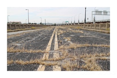
 

Even the weeds have to fend for themselves

Too dangerous for city employees to step onto the bridge to spray them, the weeds are taking over

In 2004, the bridge was renamed the Cyrus Avery Route 66 Memorial Bridge, but a new fancy name didn’t make it any more structurally sound. Then, in 2008, it was closed to even pedestrians, a plan to make it safe enough to reopen to walking traffic having been costed at $15 million. Rather than spend that sort of money, the city gave the bridge a bit of a spruce up and then gated it off. This was after surveyors decided that the bridge was too unsafe to even walk on. I suspect they probably don’t even want you to look at it that hard. The blacktop on the bridge is actually just a waterproof coating and the bridge is too weak to hold up another layer of asphalt. The city sprays the weeds occasionally, but even that is considered risky.

The 'Cyrus Avery Memorial Bridge' from the Cyrus Avery Memorial Plaza. Those Tulsans are proud of their native son.

Looking down the Cyrus Avery Memorial Bridge from the Cyrus Avery Centennial Plaza. Tulsa is proud of its native son

Now, I have to say I didn’t know all this when I found myself at the 11th Street Bridge one grey October morning. I don’t know why a side gate was open, but even if I had realised that there was a distinct possibility a hole might open up underneath me and plunge me into the muddy waters of the Arkansas River, then I would probably still have walked its length. Only afterwards did I realise how lucky I was to have had that chance.

THE MAN WHO WROTE ROUTE 66

150076645.EoicnvWE.AGuideBookToHighway66

There is one man – other than, of course, Cyrus Avery – to whom Route 66 aficionados owe a debt of gratitude. Yet most people know very little about Jack DeVere Rittenhouse, other than the fact that he wrote one of the seminal works on the Mother Road.

In 1946, Rittenhouse published A Guide Book to Highway 66, not only the first book on Route 66, then only two decades old, but the first to chronicle any major highway in the USA. When that book was reprinted in 1988, Rittenhouse wrote the foreword, which is how we know that he undertook the trip in a 1939 American Bantam. For the time, it was tiny – even to modern eyes it looks like the sort of car Noddy or Minnie Mouse might have driven and, in fact, a 1938 American Bantam was the inspiration for Donald Duck’s car. Rittenhouse doesn’t even tell us which model he drove, although it seems likely, as he refers to the lack of trunk, that it was a four-seater Model 60.

Jack Rittenhouse was born in Kalamazoo, Michigan, in 1912 and developed a love of books in childhood. When he was little more than a toddler, his family moved to Arizona, although he returned east as a young man and attended Indiana State Teachers College for three years until the Depression forced him to leave and get a job. Unfortunately his first job, writing book reviews at the Fort Wayne Journal-Gazette didn’t pay, and the young Jack made a few dollars by selling his review copies to libraries. Little is known of his early personal life, although he married Beulah Rose Scherrer on 17th May 1935 in Elkhart, Indiana when she was just 19 years old. There couldn’t have been much of a honeymoon for the very next month, Rittenhouse was riding freight trains to New York City to search for work in publishing.

He was employed by Park Row Books & Magazines in lower Manhattan where he sold used books for six months. But, by 1936, he was off riding freight trains across the country. What Beulah thought of this is not on record, nor what she did while he was off seeing the country, although he was clearly home on occasion because the marriage produced a son, David Kinsey, who was born in Fort Wayne, Indiana, in May 1938.

Returning to New York City, he found work with Alfred A Knopf before moving into advertising because it paid better (he did, however, continue to write a column for the Journal-Gazette, still selling off the books when he’d finished with them). When the Second World War came, he was exempt from joining up and was instead employed writing training manuals for the US Air Force. By now, his marriage to Beulah had ended in divorce and he was living in Chicago, where he met his second wife, Charlotte Jewell High, ten years his junior. They were married in 1944 in Missouri. His job in advertising took them to Los Angeles and along the way Rittenhouse realised that, with the war over, people would want to travel for pleasure and the freedom of the highway, particularly those servicemen and women from the Mid West and the East Coast who had been stationed in California, and they would use Route 66.

So, taking to the road again, this time in his little automobile rather than hopping trains, he began on his travel guide. One presumes Charlotte was a tolerant lady. He researched, wrote, designed and self-published A Guide Book to Highway 66, even drawing the maps and little illustrations, working out mileages and documenting the gas stations, tourist cabins and motels in each place along the road. He printed 3000 copies and sold them for a dollar apiece. In the rather poignant last line of the book, Rittenhouse wrote ‘If you have any suggestions on improving this Guide Book, address them to the publisher, so they can be included in future editions.’ Poignant because there were no future editions and it’s true to say that A Guide Book to Highway 66 was not a runaway success. In fact, the ‘second edition’ wouldn’t come until 1988 and that, of course, would be an accurate facsimile of the original book rather than contain any updates.

For the next few years, Rittenhouse hopped between selling rare books and working in advertising, as well as running his own one-man publisher, the Stagecoach Press. In 1952 he began his own agency, selling it to the Marsteller Company in 1959. The following year, he devoted his time to the Stagecoach Press, producing a number of titles. The publishing house went into hibernation when, after two years at the Museum of New Mexico Press, he joined the staff of the University of New Mexico Press where he worked until he retired in 1978 and promptly started up the Stagecoach once more. However, when the guide was reprinted in 1988, it was with his old employers rather than the Stagecoach Press.

Having fallen in love with New Mexico, he and Charlotte settled in Albuquerque, while Rittenhouse took great pleasure in documenting ghost towns, Indian ruins, mining camps and anywhere that ever had a post office, and many of his photographs are in the Rittenhouse Collection at the New Mexico State University Library.

Charlotte lived to the age of 90,surviving longer than her husband and all three of their children, each of whom died relatively young. Douglas died in 2001 in Texas aged 54; Susan passed the following year at the age of 49, also in Texas, while her sister Anne was just short of 55 when she died in California, having moved there with her husband, Harry Briley, in 1976.

Jack D Rittenhouse died in 1991, having lived long enough to see his little guide become a late success among a whole new generation for whom the Mother Road means nostalgia rather than freedom. Now it’s referred to and quoted by just about anyone who ever writes a word about Route 66, as well as becoming a glovebook essential, just as he intended more than half a century ago.

jack and anne

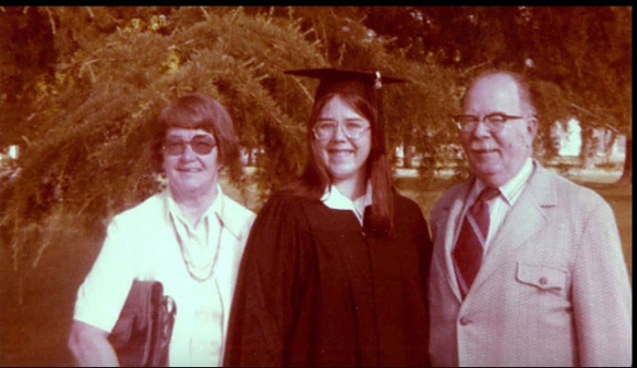
JACK AND CHARLOTTE RITTENHOUSE WITH THEIR DAUGHTER ANNE AT HER GRADUATION

SANTA CLAUS IS COMIN’ TO TOWN

10987480_846958348705334_1587210427171755057_o

THE OLD GAS STATION

Santa Claus is north-west of Kingman on US 93 and began life in 1937 when Los Angeles realtor Nina Talbot bought 80 acres in Arizona and began a motel (originally called the Kit Carson Guest House). For reasons best known to Mrs Talbot, she decided to give the place a Santa Claus theme, probably with the intention of attracting buyers for the surrounding lots. She did claim to be the biggest real estate agent in the area, although that may have had more to do with the fact that she weighed over 22 stone than her business acumen.

674b1a96f9a5094e8f5fc34aea0d4b46

IN THE 1940S, THIS GIANT BILLBOARD ENTICED VISITORS AS THEY PASSED OVER THE HOOVER DAM

While building Santa Claus’s village in the middle of the Arizona desert seems an odd idea, it turned out to be surprisingly successful in attracting tourists, but not in selling the parcels of lands. Although it was designated a town, the only people who actually lived there were those who worked at the inn or in the US Post Office or the land sales office. Mrs Talbot sold the place in 1949 by which time it was a genuine tourist attraction.

The land sales office was converted into a Texaco station and Kit Carson’s Guest House was renamed as the Santa Claus Inn and, in the 1950s, the Christmas Tree Inn. It had Santa’s Workshop, the House of the Three Pigs and Cinderella’s Dolls House and the ‘Old 1225’ train.

SantaClausArizona2

CINDERELLA’S DOLLS HOUSE IS LONG GONE

10838139_846958345372001_2150765534970206439_o

THE DERELICT RESTAURANT

Curiously, for a roadside attraction, it had a very good air-conditioned restaurant which noted food critic Duncan Hines called one of the best in the region. (Mind you, if you know the Kingman area, you’ll know there’s not all that much competition).

Robert Heinlein wrote about it in ‘Cliff and the Calories’, a short story published in 1950, listing the menu’s dishes, while Hollywood legend Jane Russell would host a dinner for ten friends at the restaurant four years later.

11025150_846958325372003_5042151662560387084_n

WISHING WELL

Santa Claus’s busiest time was, fittingly, December of each year when, for 25 cents and a stamp, employees would write to children, the envelope postmarked Santa Claus. Thousands of letters were sent out to hopeful kids.

But, by the 1970s, Santa Claus was in terminal decline. Although, back in the 1950s, there had been plans to capitalise on the Christmas theme by setting out streets with festive names (like Prancer Parkway), people only stopped in Santa Claus long enough to eat a meal or fill their tanks. It was up for sale for $95,000 in 1983, the then owner turning down an offer of $50,000 because he felt it was worth more. He relisted it in 1988 for $52,500. It’s still for sale. It was removed from the Arizona state map, the last remaining businesses closed in 1995, and the surviving residents moved out, too.

54ebde01290ce_-_little-pig-house-2-lgn

THE HOUSE OF THE THIRD LITTLE PIG AT ITS PRIME

11024742_846958338705335_1281485625939466336_n

THE HOUSE OF THE THIRD LITTLE PIG TODAY

santa claus 1940

SANTA CLAUS GAS STATION IN 1940 WITH CINDERELLA’S DOLLS HOUSE IN THE BACKGROUND

Sadly, its roadside location in the middle of nowhere, the very thing that made it a success for weary travellers on the way to Las Vegas, has been its downfall as vandals moved in. And children’s letters to Father Christmas? They now go to Santa Claus, Indiana.

UPDATE: And then, ironically just before Christmas 2021, it was gone. Now all that remains is a patch of waste land and an old billboard.

54ebd52f089cf_-_christmas-tree-inn-arizona-1951

A GRAVE IN THE DESERT

Just short of the ruins of Palmetto, Nevada, is the grave of Clyde Marshall Hart, born on May 7th 1903 and who died of diphtheria on December 3rd 1906. Apparently his 2-year-old brother Kenneth also passed just five weeks later. That is according to the official records, although the Blair News, a local newspaper of the time, reported that the boys died just a week apart.

Clyde was two years old himself when his parents, Victor and Lydia, moved to Palmetto from Santa Rosa, California, no doubt hopeful of making that big strike and never dreaming they would lose both their sons so tragically. The marker only mentions Clyde, and people have often assumed that Kenneth was buried with him. However the little boy lies alone, his younger brother having died and been buried in Silver Peak, another town to the north west. The Blair News reported that Mrs Hart had ‘been quite ill for several days prior to starting for California, her illness being aggravated by the mental anguish of the loss of the children in so short a time.’

After burying their children, the Harts continued back to California; Lydia gave birth to a son, Alan, almost exactly a year to the day after Clyde’s death, and a daughter, Evelyn, in 1910. Both Lydia and Victor lived into old age, Victor dying in 1958 at the age of 80 and Lydia living until she was 97 and they are buried beside each other in the Oddfellows Cemetery in Sacramento. Having lost two children so young, it must have been a consolation that their son and daughter lived long and full lives. Alan died in 1994 and Evelyn just nine years ago aged 96. Did the family ever come back to Palmetto to visit the grave or was it too painful a part of their life?

At some point in the past, someone decided that the little boy’s grave should not just disappear into the landscape. It’s highly unlikely that his parents erected the railings and definitely not the original headstone which mistakenly gives Clyde the initial ‘W’, as well as inscribing the wrong year of death.

I thought at first how odd it was that there are no other graves in the area, but because Palmetto existed for such a short time – the silver that was struck lasted barely a year – it could be that the little Hart boys were the only people to die out in this lonely place. But the toys and paraphernalia on the grave (I left a toy car) show that they are not forgotten.

SOUTH OF DEVILS GATE

Silver City, Nevada, was established in 1850 and had an exciting first few years. In the Paiute War of May 1860, the townspeople constructed a wooden cannon for protection, while one of the first stamp mills in Nevada was built later that year. No, before you ask, I have no clue how a wooden cannon is constructed but I suspect that, for the good of not only the Paiute but the folks operating it, it was never used.

By 1861, it had a population of around 1200, with accompanying saloons, hotels and boarding houses, as well as stabling for those travelling between the Comstock Lode mines of Virginia City and processing mills. Devils Gate, however, was a frequent haunt of highwaymen. Devils Gate, to the north of Silver City, was a toll road (now the US-342) which shortened the journey to Gold Hill and Virginia City and cut out the winding Occidental Grade of what is now US-341. Unfortunately, the 342 was closed for roadwork while I was there, meaning I had to take the long twisty route to Gold Hill. Twice, actually, because I got lost. It’s not the sort of road you really want to do twice if you don’t have to…

Silver City managed to thrive until the completion of the Virginia & Truckee Railroad in 1869 after which the population quickly moved away. Now about 100 or so people live there, most of whom probably knew I was there. It is a little bit The Hills Have Eyes. Apparently, the cemetery is worth a visit, but it appeared to be on the other side of the road closure.

NO ROOM AT THE HENNING

This is another salutary tale of how you should never presume that things will be forever. Perhaps, in Europe, we tend to think of Route 66 as preserved in aspic. But, even if a building is on the National Register of Historic Places, it offers little protection, unlike the UK’s own listing of historic buildings. Many never even make it as far as the register.

And the Henning Motel in Newberry Springs on the California stretch of Route 66 wasn’t particularly noteworthy. If it were not for the sign, then most people would have taken a photo of the Bagdad Café next door and probably not bothered to raise their cameras for the single storey white motel. No-one knows much about the Henning, least of all why it had an impressive neon sign for what was a tiny motel with just a handful of rooms. Unusually, it was constructed as one building, unlike the cabins of a similar vintage in Amboy and Chambless down the road; as Jack Rittenhouse only spoke of tourist cabins at Newberry Springs in his 1946 guide, it’s fair to assume the motel was built in the 1950s. I found a matchbook that appears to be from the 1930s or 40s which advertises ‘The Henning Motel, 400 East Main Street, Barstow’. It’s possible that the owners moved out here in the 1950s – the Barstow address is now an empty lot, so no clues there.

Look closely at one of the photos of the decaying motel and you will see the reason for its death. Interstate 40 bypassed Route 60 in 1973, running a few yards behind the motel, although it might as well be a hundred miles away. The Henning struggled on for a while – hell, it was even famous for a moment when the film ‘Bagdad Café’ was filmed at what was then called the Sidewinder Café in 1987.

For years, the building has been quietly mouldering away. A hand painted sign outside with a Flagstaff telephone number invited offers of $25,000 for the building and three and a half acres of land. But the motel moved beyond economic repair years ago, while land is not in short supply out here. I passed it fairly regularly, sometimes taking a photo, sometimes not.

And then this summer it was gone. Cleared, the concrete pad the only sign something was once here. The sign is clinging on, overseeing an empty lot and lost memories.

GOODBYE TO THE CLUB CAFE

12113376_961168507284317_6902935718774061004_o

On a grey and overcast October afternoon, I stopped by at the remains of the Club Cafe in Santa Rosa, New Mexico. I didn’t take much notice of the guy with a tape measure wandering around, but I decided not to clamber through the window opening and have a last walk round the skeleton of the building. Sometimes you meet people as intrigued by a building as you and sometimes you skulk past them, eyes not meeting, knowing they don’t see what you see.

The Club Café opened in 1935, five years after the Santa Rosa stretch of Route 66 was completed; its blue-tiled frontage and smiling ‘Fat Man’ logo, a happy gent wearing a polka dot tie and looking delighted after, presumably, dining on the Club Café’s home cooking, became well-known to thousands of travellers on Route 66.

12141104_961168513950983_1831697896696195064_o

But, by the time I-40 bypassed the New Mexico town, people didn’t want home cooking. They wanted a quick stop at one of the generic fast food places just off the interstate. The Fat Man looked dated in the face of the ubiquitous clown and southern gentleman. In 1992, the Club Café closed its doors forever. It was bought by Joseph and Christiana Campos who planned to reopen it, but the building had suffered too much

11722555_961168523950982_5862782416910915442_o

over the years. They couldn’t save the Club Café, but they got permission to use the Fat Man logo at their restaurant, Joseph’s Bar and Grill, down the road.

On the low retaining wall in the parking lot were painted signs from a happier time, commemorating ratings in the Mobil Travel Guide as well as Chef Ron Chavez, who owned the restaurants for over twenty years. He’d been a cook here in the 1950s and then bought the café in the 1970s. Moving to Taos, he wrote poetry until his death last October, never seeing the final demise of the café he loved. The Club Café’s sign still stands (others were taken down and left on the site – they are now gone) for now, although its fate seems uncertain. The guy with the tape measure gave it a cursory glance and moved on.

12028629_961168500617651_6556322689289982829_o

The Club Café has always been there every time I’ve passed through Santa Rosa. I thought it always would be. But, for once, I stopped and took a few photos. Had I known that the bulldozers would be moving in the next morning, I would have run the camera red hot. I guess these may be some of the last photos ever taken of the Club Cafe.

12113524_961168520617649_6878929466243664445_o

MOVE ALONG, NOTHING TO SEE

10478986_887202918014210_1233757165267706460_n

NOTHING, MOHAVE COUNTY, ARIZONA

Nothing is a modern ghost town. Well, it was never even really a town. It was established in 1977, 100 miles north west of Phoenix on US-93 between Kingman and Wickenburg; essentially a gas station, small mart and a ADOT motorist callbox. It did, however, have a town sign which read ‘Town of Nothing Arizona. Founded 1977. Elevation 3269ft. The staunch citizens of Nothing are full of Hope, Faith, and Believe in the work ethic. Thru-the-years-these dedicated people had faith in Nothing, hoped for Nothing, worked at Nothing, for Nothing.’

By 2005 it was abandoned and the gas station began to collapse a few years later. There was a brief hope that Nothing would come to something when maker of bespoke wood-fired pizza ovens, Mike ‘Pizzaman Mike’ Jensen bought the site and opened a pizza parlour briefly in 2009. As well as tempting motorists with pizza, he also had plans for RV parking, cabins, a mini mart and truck parking.

But he found that the battle against County Health, Building, Planning, Zoning and ADOT was impossible. Mike says; “The Health Dept. refused to issue a Mobile Food License if I was Based in Nothing. Building, Planning and Zoning stated it was residential and I needed to apply for commercial and basically start over as Nothing exists in Nothing, while the DOT wanted me to pave the whole front and maintain it as my right of way. With all this said and done, since I could not sell anything in Nothing – not even water without a hefty fine – it left me no choice but to leave Nothing. So when you own Nothing, you have Nothing to lose.

Now the gas station has gone completely, the one remaining building is boarded up and the posted site is full of rubble. The planned route of I-11 goes straight through here, so one day there may truly be nothing at Nothing.

11269743_887202911347544_618693782726620544_n

11038746_887202914680877_6000104896075802142_o

Down this road that I must travel

I make no apologies for a title stolen from an 1980s pop song. After all, most of the good road quotes are already taken.

Unlike the roads.

They still exist, running north to south, east to west, sometimes through cardinal points that you didn’t know existed and that would make your head spin to comprehend. This is a blog about roads and the snapshots of the past that litter every yard of tarmac or concrete or dirt. It’s the things you never noticed and the things you’ve seen a hundred times and yet didn’t see. It’s somewhere to put my photos. It’s somewhere to justify the hours I spend distracted, butterfly-minded, by the curious and the commonplace. It’s another road to travel.

And I have no idea where this one is going…

IMG_1039

All text and photographs unless otherwise stipulated remains copyright of Blue Miller. Please do not use without an appropriate credit and link to http://www.neverquitelost.com. Thank you.